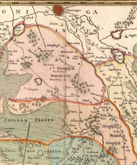
The wide world of Cornelis Pijnacker

- 11 May till 1 September 2019
- Drents Museum
From 11th May until 1st September 2019 the Drents Museum presents a small exhibition The wide world of Cornelis Pijnacker.
Central to this are Cornelis Pijnacker (1570-1645) and the first map of the province of Drenthe, that Pijnacker made in his old age in 1634. One reason for this exhibition is the publication of a book about Pijnacker’s life in 2018. The exhibition is a collaboration between the Drents Archief and the Drents Museum.
Cornelis Pijnacker (1570-1645) was not originally a cartographer. The first map of Drenthe from 1634 was a result of the enthusiastic hobby of this special man. Pijnacker was professor of law for many years (including in Groningen) and travelled twice to North Africa as ambassador. Roelof van Echten, representative and later Drost of Drenthe, brought Pijnacker to Drenthe in 1629 to serve him as legal adviser. Pijnacker’s love for maps proved useful, as Van Echten wanted to stimulate the growth of his region. Pijnacker could help him put Drenthe on the map - literally, as previously there was no map of the region.
Exhibition
You can see several editions of Pijnacker’s map of Drenthe (and adjacent Westerwolde) in the exhibition. The influence of his map on the neighbouring regions is clear from the maps of Groningen, Friesland and Overijssel. Pijnacker’s map of Drenthe was included in the world famous atlases of the Amsterdam publishers Hondius and Blaeu, an example of which you can admire. The importance of Pijnacker’s map is apparent from the fact that a reproduction of the map hangs on the wall of many Drenthe living rooms.
The Dutch language book De wijde wereld van Cornelis Pijnacker (1570-1645) [auteurs Paul Brood, Gerard van Krieken en Jan Spoelder] is available in the Museumshop. The book is a publication of WBOOKS and costs € 24,95.
Related pages
-
Antonio López (online exhibition)
![]()
-
The Largest Doll’s House in the Netherlands
![]()
-
Labyrinthia
![]()
-
DMspotlight - Wilhelmina Proos
![]()


